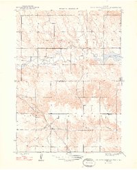
1948 Map of Box Butte Reservoir West
USGS Topo · Published 1948About this map
The Niobrara River winds through this high plains landscape on the border of Dawes and Box Butte counties, appearing here shortly after the completion of the dam that created the Box Butte Reservoir. This postwar era survey shows a rural infrastructure defined by scattered education and heavy rail, where small outposts like Sch No 62 and Sch No 50 served the local ranching or farming families. To the south, the Chicago Burlington and Quincy railroad cuts a diagonal path across the terrain, crossing Sand Canyon as it moves toward the northwestern corner of the state. The map captures a transition in water management and land use, documenting the early years of the reservoir alongside established drainage patterns like Willow Creek and the township divisions of Leonard and Lawson.
Find a feature on this map
10 named features on this map. Tap any name to fly to it.
Don’t see what you’re looking for? This feature index may not catch every label — zoom into the map to look around manually.
Map Details
Editions of this 1948 Box Butte Reservoir West Map
2 editions found
Other maps of this area

1946 · Nonpareil
USGS Topo · 1:24,000

1946 · Box Butte Reservoir West
USGS Topo · 1:24,000

1948 · Box Butte Reservoir West
USGS Topo · 1:24,000

1948 · Hemingford
USGS Topo · 1:24,000

1948 · Nonpareil
USGS Topo · 1:24,000

1948 · Box Butte Reservoir East
USGS Topo · 1:24,000

1951 · Marsland
USGS Topo · 1:62,500

1955 · Alliance
USGS Topo · 1:250,000

1957 · Alliance
USGS Topo · 1:250,000

1958 · Alliance
USGS Topo · 1:250,000