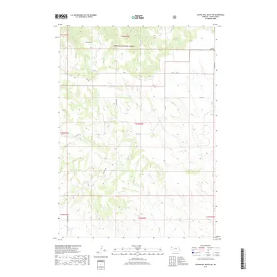
2017 Map of Coffee Mill Butte SW
USGS Topo · Published 2017About this map
Nebraska National Forest encompasses the northern portion of this Dawes County landscape, where the terrain breaks into a network of drainages feeding the White River watershed. The area is defined by a series of north-flowing seasonal streams, including W Ash Cr, Little Cr, and E-Ash Cr, which carve through the high plains topography. Settlement patterns are sparse, dictated by the rugged breaks and ranching requirements of the early 21st century.
Find a feature on this map
21 named features on this map. Tap any name to fly to it.
Don’t see what you’re looking for? This feature index may not catch every label — zoom into the map to look around manually.
Map Details
Editions of this 2017 Coffee Mill Butte SW Map
This is the sole edition of this map. No revisions or reprints were ever made.
Other maps of this area

1946 · Box Butte Reservoir West
USGS Topo · 1:24,000

1948 · Box Butte Reservoir West
USGS Topo · 1:24,000

1948 · Box Butte Reservoir East
USGS Topo · 1:24,000

1951 · Marsland
USGS Topo · 1:62,500

1955 · Alliance
USGS Topo · 1:250,000

1957 · Alliance
USGS Topo · 1:250,000

1958 · Alliance
USGS Topo · 1:250,000

1980 · Crow Butte
USGS Topo · 1:24,000
1980 · Coffee Mill Butte SE
USGS Topo · 1:24,000
1980 · Coffee Mill Butte
USGS Topo · 1:24,000