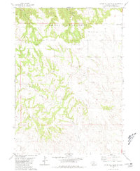
1980 Map of Coffee Mill Butte SW
USGS Topo · Published 1981About this map
The Nebraska National Forest blankets the northern canyons of this Dawes County landscape, where the terrain breaks sharply from the high plateaus. This 1980 survey captures a rural community defined by its remote schools and churches, most notably the Highland Center Sch and nearby Highland Center Cem located along the eastern boundary. The intricate drainage network is a defining characteristic of the area, with Cottonwood Creek and Willow Creek carving deep paths through the soil, while the Willow Creek Ch serves as a lone spiritual landmark in the southern reaches.
Find a feature on this map
19 named features on this map. Tap any name to fly to it.
Don’t see what you’re looking for? This feature index may not catch every label — zoom into the map to look around manually.
Map Details
Editions of this 1980 Coffee Mill Butte SW Map
This is the sole edition of this map. No revisions or reprints were ever made.
Other maps of this area

1946 · Box Butte Reservoir West
USGS Topo · 1:24,000

1948 · Box Butte Reservoir West
USGS Topo · 1:24,000

1948 · Box Butte Reservoir East
USGS Topo · 1:24,000

1951 · Marsland
USGS Topo · 1:62,500

1955 · Alliance
USGS Topo · 1:250,000

1957 · Alliance
USGS Topo · 1:250,000

1958 · Alliance
USGS Topo · 1:250,000

1980 · Crow Butte
USGS Topo · 1:24,000
1980 · Coffee Mill Butte SE
USGS Topo · 1:24,000
1980 · Coffee Mill Butte
USGS Topo · 1:24,000