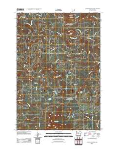
2011 Map of Coffin Mountain
USGS Topo · Published 2011About this map
Coffin Mountain Lookout stands as a prominent sentinel over this heavily forested portion of the Cascade Range in Linn County. This early 21st-century survey reveals a landscape defined by an extensive network of forestry access roads, including Upper Blowout Rd and Straight Creek Rd, which provide access to the area's many high-elevation water bodies. Hidden among the peaks like Three Pyramids and Pinnacle Peak are several small mountain lakes, such as Daly Lake, Parish Lake, and Don Lake. The hydrography is dominated by the headwaters of numerous creeks, including Blowout Creek and Pyramid Creek, all eventually feeding toward the North Santiam River at the map's southeastern edge. The density of named ridges and peaks, from Trappers Butte to Scar Mountain, underscores the complex verticality of this managed forest environment.
Find a feature on this map
34 named features on this map. Tap any name to fly to it.
Don’t see what you’re looking for? This feature index may not catch every label — zoom into the map to look around manually.
Map Details
Editions of this 2011 Coffin Mountain Map
This is the sole edition of this map. No revisions or reprints were ever made.
Other maps of this area

1927 · Mt. Jefferson
USGS Topo · 1:125,000

1929 · Mill City
USGS Topo · 1:125,000

1929 · Three Sisters
USGS Topo · 1:125,000

1930 · Mt. Jefferson
USGS Topo · 1:125,000

1932 · Three Sisters
USGS Topo · 1:125,000

1934 · Mc Kenzie Bridge
USGS Topo · 1:96,000

1940 · Mc Kenzie Bridge
USGS Topo · 1:125,000

1953 · Salem
USGS Topo · 1:250,000

1954 · Salem
USGS Topo · 1:250,000

1955 · Echo Mountain
USGS Topo · 1:62,500