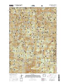
2017 Map of Coffin Mountain
USGS Topo · Published 2017About this map
Coffin Lookout stands atop the high peaks of the Willamette National Forest, overlooking a terrain defined by steep ridges and glacial lakes. This landscape in the t11s r6e and t12s r7e townships is marked by the presence of significant high-altitude landmarks including Bachelor Mountain and the distinct formation of the Three Pyramids. A network of Forest Service roads, such as Upper Blowout Rd and the Straight Creek Rd, provides access to these elevations and the numerous small lakes scattered throughout, including Riggs Lake, Parish Lake, and Tule Lake. The southern edge of this area is bordered by the North Santiam River, where the elevation drops toward the river valley. Numerous creeks like Blowout Cr and Pyramid Cr drain the watershed, illustrating the complex drainage patterns that shape these Cascades foothills.
Find a feature on this map
69 named features on this map. Tap any name to fly to it.
Don’t see what you’re looking for? This feature index may not catch every label — zoom into the map to look around manually.
Map Details
Editions of this 2017 Coffin Mountain Map
This is the sole edition of this map. No revisions or reprints were ever made.
Other maps of this area

1927 · Mt. Jefferson
USGS Topo · 1:125,000

1929 · Mill City
USGS Topo · 1:125,000

1929 · Three Sisters
USGS Topo · 1:125,000

1930 · Mt. Jefferson
USGS Topo · 1:125,000

1932 · Three Sisters
USGS Topo · 1:125,000

1934 · Mc Kenzie Bridge
USGS Topo · 1:96,000

1940 · Mc Kenzie Bridge
USGS Topo · 1:125,000

1953 · Salem
USGS Topo · 1:250,000

1954 · Salem
USGS Topo · 1:250,000

1955 · Echo Mountain
USGS Topo · 1:62,500