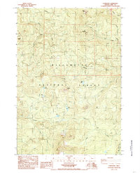
1984 Map of Coffin Mountain
USGS Topo · Published 1985About this map
Willamette National Forest dominates this mid-1980s landscape in Linn County, where high ridges and deeply cut creek drainages define the wilderness character. The terrain is anchored by several prominent peaks, including Coffin Mtn, Buck Mountain, and the striking Three Pyramids in the southern sector. A network of high-elevation water bodies like Daly Lake, Parish Lake, and Riggs Lake are distributed across the slopes, providing a detailed look at the hydrology of the western Cascades before modern climate shifts.
Find a feature on this map
29 named features on this map. Tap any name to fly to it.
Don’t see what you’re looking for? This feature index may not catch every label — zoom into the map to look around manually.
Map Details
Editions of this 1984 Coffin Mountain Map
This is the sole edition of this map. No revisions or reprints were ever made.
Other maps of this area

1927 · Mt. Jefferson
USGS Topo · 1:125,000

1929 · Mill City
USGS Topo · 1:125,000

1929 · Three Sisters
USGS Topo · 1:125,000

1930 · Mt. Jefferson
USGS Topo · 1:125,000

1932 · Three Sisters
USGS Topo · 1:125,000

1934 · Mc Kenzie Bridge
USGS Topo · 1:96,000

1940 · Mc Kenzie Bridge
USGS Topo · 1:125,000

1953 · Salem
USGS Topo · 1:250,000

1954 · Salem
USGS Topo · 1:250,000

1955 · Echo Mountain
USGS Topo · 1:62,500