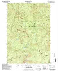
1994 Map of Coffin Mountain
USGS Topo · Published 1998About this map
Willamette National Forest encompasses the high-altitude terrain of the Cascades, dominated by the prominent peaks of Coffin Mountain Lookout and the Three Pyramids. The landscape is a network of drainage basins, where Blowout Creek and Pyramid Creek carve through the timbered slopes. This 1994 snapshot of the Detroit Ranger District reveals the resource-management priorities of the era, balancing recreational infrastructure like the Old Cascade Crest Trail with industrial activity indicated by several Quarries and gravel pits situated near the Detroit Sweet Home Rd.
Find a feature on this map
46 named features on this map. Tap any name to fly to it.
Don’t see what you’re looking for? This feature index may not catch every label — zoom into the map to look around manually.
Map Details
Editions of this 1994 Coffin Mountain Map
This is the sole edition of this map. No revisions or reprints were ever made.
Other maps of this area

1927 · Mt. Jefferson
USGS Topo · 1:125,000

1929 · Mill City
USGS Topo · 1:125,000

1929 · Three Sisters
USGS Topo · 1:125,000

1930 · Mt. Jefferson
USGS Topo · 1:125,000

1932 · Three Sisters
USGS Topo · 1:125,000

1934 · Mc Kenzie Bridge
USGS Topo · 1:96,000

1940 · Mc Kenzie Bridge
USGS Topo · 1:125,000

1953 · Salem
USGS Topo · 1:250,000

1954 · Salem
USGS Topo · 1:250,000

1955 · Echo Mountain
USGS Topo · 1:62,500