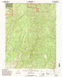
1995 Map of Cohasset
USGS Topo · Published 1998About this map
Cohasset Ridge and the surrounding timberlands of the Lassen National Forest define this landscape, where the ridges and canyons of the Sierra Nevada foothills transition toward the Sacramento Valley. The map documents the scattered rural settlements of Cohasset and Forest Ranch during the mid-1990s, revealing a landscape shaped by both historic industry and modern utility. Evidence of early settlement appears at the Anderson Mill (Site), while the high points are occupied by communication infrastructure, including several radio towers and the Platte Mountain Lookout.
Find a feature on this map
46 named features on this map. Tap any name to fly to it.
Don’t see what you’re looking for? This feature index may not catch every label — zoom into the map to look around manually.
Map Details
Editions of this 1995 Cohasset Map
This is the sole edition of this map. No revisions or reprints were ever made.
Other maps of this area

1886 · Lassen Peak
USGS Topo · 1:250,000

1891 · Chico
USGS Topo · 1:125,000

1892 · Lassen Peak
USGS Topo · 1:250,000

1893 · Chico
USGS Topo · 1:125,000

1894 · Lassen Peak
USGS Topo · 1:250,000

1895 · Chico
USGS Topo · 1:125,000

1912 · Keefers
USGS Topo · 1:31,680

1935 · Paynes Creek
USGS Topo · 1:96,000

1941 · Mineral
USGS Topo · 1:125,000

1944 · Richardson Springs
USGS Topo · 1:62,500