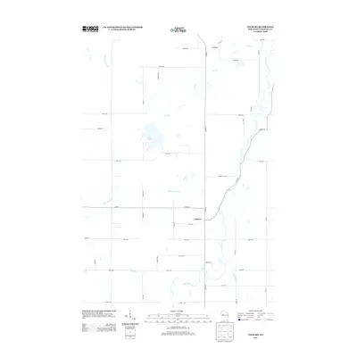
2013 Map of Colburn
USGS Topo · Published 2013About this map
Colburn sits at the heart of this Northwoods landscape, where a dense network of tributaries feeds the Yellow River. The area is defined by its watercourses, including the meandering paths of Big Drywood Cr and Little Drywood Cr, which drain the surrounding woodlands and agricultural plots. Pike Lake serves as a prominent local landmark in the northwestern quadrant, connected to the broader hydrologic system via Pike Cr. The settlement pattern follows a rigid section-line grid, though roads like Quimet Hills Rd and River Rd deviate to accommodate the natural terrain and river bends. This survey documents the rural character of Chippewa County in the early 21st century, showing a mix of established family-named routes such as Nerdrum Rd and Lancor Rd alongside the primary transit corridors of Co Hwy-D and Co Hwy-S.
Find a feature on this map
44 named features on this map. Tap any name to fly to it.
Don’t see what you’re looking for? This feature index may not catch every label — zoom into the map to look around manually.
Map Details
Editions of this 2013 Colburn Map
This is the sole edition of this map. No revisions or reprints were ever made.
Other maps of this area

1951 · Cornell
USGS Topo · 1:62,500

1951 · Gilman
USGS Topo · 1:62,500

1952 · Cadott
USGS Topo · 1:62,500

1952 · Stanley
USGS Topo · 1:62,500

1953 · Eau Claire
USGS Topo · 1:250,000

1953 · Rice Lake
USGS Topo · 1:250,000

1958 · Eau Claire
USGS Topo · 1:250,000

1959 · Rice Lake
USGS Topo · 1:250,000

1964 · Eau Claire
USGS Topo · 1:250,000
1973 · Colburn
USGS Topo · 1:24,000