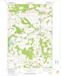
1973 Map of Coleman
USGS Topo · Published 1977About this map
The Chicago Milwaukee St Paul and Pacific railroad forms the central north-south spine of this Marinette County landscape, connecting the neighboring villages of Pound and Coleman. In the early 1970s, these communities served as agricultural and transport hubs, supported by several local cemeteries including St Leos Cem, St Johns Cem, and Trinity Cem. The terrain is defined by a complex network of waterways, where the Peshtigo River meets the Little Peshtigo River, and smaller streams like Whisky Creek and South Branch Beaver Creek drain the surrounding fields.
Find a feature on this map
49 named features on this map. Tap any name to fly to it.
Don’t see what you’re looking for? This feature index may not catch every label — zoom into the map to look around manually.
Map Details
Editions of this 1973 Coleman Map
This is the sole edition of this map. No revisions or reprints were ever made.
Other maps of this area

1939 · Porterfield
USGS Topo · 1:48,000

1941 · Coleman
USGS Topo · 1:48,000

1942 · Coleman
USGS Topo · 1:48,000

1942 · Porterfield
USGS Topo · 1:48,000

1950 · Coleman
USGS Topo · 1:48,000

1954 · Iron Mountain
USGS Topo · 1:250,000

1954 · Escanaba
USGS Topo · 1:250,000

1954 · Manitowoc
USGS Topo · 1:250,000

1955 · Green Bay
USGS Topo · 1:250,000

1956 · Oconto
USGS Topo · 1:62,500