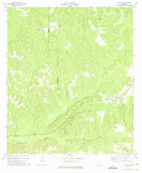
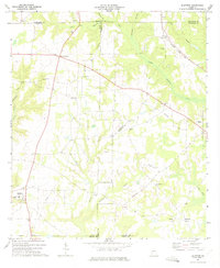
1973 Map of Coleman
USGS Topo · Published 1975About this map
The boundary between Clay Co and Randolph Co runs through the heart of this landscape, where early 1970s agricultural patterns meet a complex network of creeks. The town of Coleman serves as the primary hub, situated along an Old Railroad Grade that speaks to the area's former transit infrastructure. Rural life is anchored by established congregations at Shiloh Ch, Shorter Chapel, and Pleasant Hill Ch, while smaller communities like Cotton Hill, Bethel, and Pecan are scattered across the terrain. Waterways such as Waukeefriskee Creek and the long, winding Cemochechobee Creek define the topography, illustrating the drainage patterns essential to this corner of Georgia. For researchers, the presence of New Hope Cem and several unnamed Cem sites provide specific points of interest for genealogical study within this quiet farming region.
Find a feature on this map
21 named features on this map. Tap any name to fly to it.
Don’t see what you’re looking for? This feature index may not catch every label — zoom into the map to look around manually.
Map Details
Editions of this 1973 Coleman Map
This is the sole edition of this map. No revisions or reprints were ever made.
Other maps of this area

1953 · Dothan
USGS Topo · 1:250,000

1954 · Dothan
USGS Topo · 1:250,000

1955 · Dothan
USGS Topo · 1:250,000

1967 · Hatcher
USGS Topo · 1:24,000

1969 · Fort Gaines
USGS Topo · 1:24,000

1969 · Fort Gaines NE
USGS Topo · 1:24,000
1972 · Cuthbert
USGS Topo · 1:24,000
1973 · Morris
USGS Topo · 1:24,000
1973 · Carnegie
USGS Topo · 1:24,000
1973 · Bluffton
USGS Topo · 1:24,000