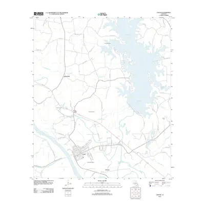
2012 Map of Colfax
USGS Topo · Published 2012About this map
Colfax serves as the focal point of this Grant Parish landscape, situated along a complex network of waterways including the Red River, Cane River, and Bayou Rigolette. The town's grid is detailed down to individual streets like Eleanor St and Chester St, illustrating the community's layout near Apalachie Island. The eastern portion of the map is dominated by the sprawling, indented shoreline of Lake Iatt, featuring landmarks such as Pin Oak Island and Sunken Is. Industrial footprints are clearly visible through the Colfax Oil Field and Rock Hill Oil Field, which speak to the region's energy production. Rural settlements such as Summerfield and McNeely connect via a web of parish roads, while smaller water features like Sugarhouse Bayou and Cholera Br drain the low-lying terrain. This 2012 survey provides a comprehensive look at the intersection of river-bottom geography and local industry in central Louisiana.
Find a feature on this map
90 named features on this map. Tap any name to fly to it.
Don’t see what you’re looking for? This feature index may not catch every label — zoom into the map to look around manually.
Map Details
Editions of this 2012 Colfax Map
This is the sole edition of this map. No revisions or reprints were ever made.
Other maps of this area

1932 · Colfax NE
USGS Topo · 1:31,680

1932 · Boyce NE
USGS Topo · 1:31,680

1932 · Colfax SW
USGS Topo · 1:31,680

1932 · Colfax SE
USGS Topo · 1:31,680

1932 · Colfax NW
USGS Topo · 1:31,680

1935 · Verda
USGS Topo · 1:31,680

1936 · Colfax
USGS Topo · 1:62,500

1937 · Chopin NE
USGS Topo · 1:31,680

1937 · Aloha
USGS Topo · 1:31,680

1937 · Montgomery
USGS Topo · 1:62,500