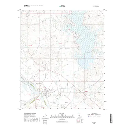
2020 Map of Colfax
USGS Topo · Published 2020About this map
Colfax serves as the focal point of this Grant Parish landscape, where the Red River carves a western boundary alongside the Cane River and Red Bayou. The settlement pattern reflects a deep connection to the complex hydrology of the region, with the massive Lake Iatt dominating the northeast and a network of smaller channels like Sugarhouse Bayou and Bayou Rigolette threading through the lowlands. This survey illustrates the intricate relationship between the town and its surrounding islands, such as Apalachie Island and Pin Oak Island, which are defined by shifting watercourses. For local history and genealogy research, the map identifies key institutional and family sites including the Grant Parish Courthouse and long-standing burial grounds like Shady Grove Cem and Corbett Cem. Small communities like Summerfield and McNeely are connected by a web of local roads, including Dartigo Rd and Patterson Rd, which navigate the many crossings of Copol Cr and Boggy Bayou.
Find a feature on this map
82 named features on this map. Tap any name to fly to it.
Don’t see what you’re looking for? This feature index may not catch every label — zoom into the map to look around manually.
Map Details
Editions of this 2020 Colfax Map
This is the sole edition of this map. No revisions or reprints were ever made.
Other maps of this area

1932 · Colfax NE
USGS Topo · 1:31,680

1932 · Boyce NE
USGS Topo · 1:31,680

1932 · Colfax SW
USGS Topo · 1:31,680

1932 · Colfax SE
USGS Topo · 1:31,680

1932 · Colfax NW
USGS Topo · 1:31,680

1935 · Verda
USGS Topo · 1:31,680

1936 · Colfax
USGS Topo · 1:62,500

1937 · Chopin NE
USGS Topo · 1:31,680

1937 · Aloha
USGS Topo · 1:31,680

1937 · Montgomery
USGS Topo · 1:62,500