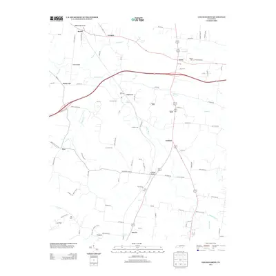
2013 Map of College Grove
USGS Topo · Published 2013About this map
The Harpeth River and its many tributaries, such as Arrington Cr and Nelson Cr, define the rural landscape of this Middle Tennessee region. A significant agricultural tradition remains visible through named properties like Benchmark Farm, Stony Point Farm, and Hartlinsdale Farm, which occupy the spaces between established settlements. The community of College Grove serves as a central hub, while smaller hamlets like Triune, Arrington, and Allisona dot the road network. The terrain is marked by prominent elevations including Patton Knob and Yancey Knob, providing a clear view of the transition from river bottomlands to the surrounding hills. Modern infrastructure, notably the path of S R 840, intersects older corridors like Lampkins Bridge Rd and Old Murfreesboro Rd, illustrating the evolution of local transit from historic wagon roads to modern regional bypasses.
Find a feature on this map
99 named features on this map. Tap any name to fly to it.
Don’t see what you’re looking for? This feature index may not catch every label — zoom into the map to look around manually.
Map Details
Editions of this 2013 College Grove Map
This is the sole edition of this map. No revisions or reprints were ever made.
Other maps of this area

1909 · Franklin
USGS Topo · 1:62,500

1936 · Chapel Hill
USGS Topo · 1:24,000

1936 · Rover
USGS Topo · 1:24,000

1936 · Rally Hill
USGS Topo · 1:24,000

1936 · Bethesda
USGS Topo · 1:24,000

1942 · Lebanon
USGS Topo · 1:100,000

1944 · Shelbyville
USGS Topo · 1:100,000

1946 · Bethesda
USGS Topo · 1:24,000
1947 · Rally Hill
USGS Topo · 1:24,000

1949 · Franklin
USGS Topo · 1:24,000