
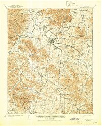
1909 Map of Franklin
USGS Topo · Published 1909About this map
Franklin serves as the hub of this Middle Tennessee landscape, where a radial network of pikes connects outlying agricultural settlements during the early 1900s. The Louisville and Nashville RR bisects the region, facilitating trade along the Harpeth River corridor between Thompsons Station and Callender. The presence of the Confederate Cemetery and numerous family-named knobs like Roper Knob and Shamblers Knob reflects the area's deep nineteenth-century roots. Educational and social life centers on institutions such as Boiling Spring Academy and Fairfield School, alongside a dense concentration of rural houses of worship including Bethel Church and Popes Chapel. The map reveals a transition from river-bottom farming to higher ground at Duck River Ridge near the southern boundary line with Maury County, where small hamlets like Bethesda and Peytonsville anchor the rural community.
Find a feature on this map
93 named features on this map. Tap any name to fly to it.
Don’t see what you’re looking for? This feature index may not catch every label — zoom into the map to look around manually.
Map Details
Editions of this 1909 Franklin Map
2 editions found
Other maps of this area

1901 · Colombia
USGS Topo · 1:125,000

1903 · Nashville
USGS Topo · 1:125,000

1930 · White Bluff
USGS Topo · 1:62,500

1932 · Hermitage
USGS Topo · 1:62,500

1932 · Nashville
USGS Topo · 1:62,500

1933 · White Bluff
USGS Topo · 1:62,500

1936 · Godwin
USGS Topo · 1:24,000

1936 · Chapel Hill
USGS Topo · 1:24,000

1936 · Rally Hill
USGS Topo · 1:24,000

1936 · Spring Hill
USGS Topo · 1:24,000