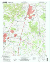
1981 Map of Franklin
USGS Topo · Published 1981About this map
Franklin and Brentwood are captured during a period of significant suburban expansion in Williamson County, where established agricultural tracts began transitioning into residential developments like Mooreland Estates and Royal Oaks. The landscape is deeply tied to the winding course of the Harpeth River and the Louisville and Nashville railroad corridor, which together define the valley's settlement patterns. Genealogists will find a high density of small family burial grounds and historical sites, including the Confederate Cem and McGavock Cem, alongside institutions such as the Harpeth Academy and Orphanage. The map also details the evolving infrastructure of the early 1980s, noting several radio towers like Radio Tower (WSM) and major interchanges such as Interchange 65, which fueled the growth of these Nashville suburbs while the Seward Hills and Knobs maintained their topographic prominence.
Find a feature on this map
92 named features on this map. Tap any name to fly to it.
Don’t see what you’re looking for? This feature index may not catch every label — zoom into the map to look around manually.
Map Details
Editions of this 1981 Franklin Map
2 editions found
Other maps of this area

1903 · Nashville
USGS Topo · 1:125,000

1909 · Franklin
USGS Topo · 1:62,500

1932 · Hermitage
USGS Topo · 1:62,500

1932 · Nashville
USGS Topo · 1:62,500

1936 · Spring Hill
USGS Topo · 1:24,000

1936 · Bethesda
USGS Topo · 1:24,000

1942 · Lebanon
USGS Topo · 1:100,000

1946 · Leipers Fork
USGS Topo · 1:24,000

1946 · Bethesda
USGS Topo · 1:24,000
1946 · Spring Hill
USGS Topo · 1:24,000
Featured Places
- Franklin, TN
- Brentwood, TN
- Jamestown, Brentwood
- Crockett Cove, Brentwood
- Concord Country Estates, Brentwood