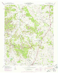
1946 Map of Spring Hill
USGS Topo · Published 1975About this map
The rolling landscape along the border of Williamson and Maury Counties is dominated by the strategic corridor of the Louisville and Nashville railroad. This 1946 survey, revised with 1967 photography, shows the agricultural and early industrial transition of the Spring Hill and Thompsons Station area. The interior is marked by numerous family and community burial grounds, such as Harrison Cem, Murfree Cem, and Walton Cem, which serve as vital markers for local genealogical research.
Find a feature on this map
66 named features on this map. Tap any name to fly to it.
Don’t see what you’re looking for? This feature index may not catch every label — zoom into the map to look around manually.
Map Details
Editions of this 1946 Spring Hill Map
3 editions found
Other maps of this area

1901 · Colombia
USGS Topo · 1:125,000

1909 · Franklin
USGS Topo · 1:62,500

1936 · Godwin
USGS Topo · 1:24,000

1936 · Rally Hill
USGS Topo · 1:24,000

1936 · Spring Hill
USGS Topo · 1:24,000

1936 · Theta
USGS Topo · 1:24,000

1936 · Carters Creek
USGS Topo · 1:24,000

1936 · Bethesda
USGS Topo · 1:24,000

1940 · Godwin
USGS Topo · 1:24,000
1941 · Godwin
USGS Topo · 1:24,000
Featured Places
- Franklin, TN
- Spring Hill, TN
- Thompson's Station, TN
- Sycamore, TN
- Country Haven Estates, Thompson's Station