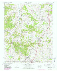
1946 Map of Spring Hill
USGS Topo · Published 1980About this map
Spring Hill and Thompsons Station anchor this mid-century survey of the rolling hills and agricultural valleys straddling the border between Williamson and Maury Counties. The landscape is defined by the Duck River Divide and Sugar Ridge, which separate the waters of the Duck River from the West Harpeth River and Murfree Fork. The rural economy of the 1940s is evident in the numerous family-named burial grounds like Harrison Cem and Murfree Cem, as well as small community centers like Burwood and Sycamore. Transport and industry are represented by the Louisville and Nashville railroad corridor, several Strip Mines in the uplands, and a Race Track near the northern boundary. The density of country churches, including West Harpeth Ch and Connection Hill Church, provides a clear view of the social fabric of these Tennessee communities before modern expansion.
Find a feature on this map
65 named features on this map. Tap any name to fly to it.
Don’t see what you’re looking for? This feature index may not catch every label — zoom into the map to look around manually.
Map Details
Editions of this 1946 Spring Hill Map
3 editions found
Other maps of this area

1901 · Colombia
USGS Topo · 1:125,000

1909 · Franklin
USGS Topo · 1:62,500

1936 · Godwin
USGS Topo · 1:24,000

1936 · Rally Hill
USGS Topo · 1:24,000

1936 · Spring Hill
USGS Topo · 1:24,000

1936 · Theta
USGS Topo · 1:24,000

1936 · Carters Creek
USGS Topo · 1:24,000

1936 · Bethesda
USGS Topo · 1:24,000

1940 · Godwin
USGS Topo · 1:24,000
1941 · Godwin
USGS Topo · 1:24,000
Featured Places
- Franklin, TN
- Spring Hill, TN
- Thompson's Station, TN
- Sycamore, TN
- Country Haven Estates, Thompson's Station