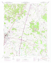
1949 Map of Franklin
USGS Topo · Published 1974About this map
The Harpeth River carves a winding path through this mid-century landscape, anchoring the development of Franklin as it begins to expand beyond its core. The town is marked by its deep historical roots, notably seen in the Confederate Cem and Mc Gavock Cem located south of the city limits near the river. This era shows a transition where traditional rural structures, such as the Orphanage and its associated Orphanage Cem in the north, coexist with modern communications like the Radio Tower (WSM).
Find a feature on this map
55 named features on this map. Tap any name to fly to it.
Don’t see what you’re looking for? This feature index may not catch every label — zoom into the map to look around manually.
Map Details
Editions of this 1949 Franklin Map
3 editions found

Other maps of this area

1903 · Nashville
USGS Topo · 1:125,000

1909 · Franklin
USGS Topo · 1:62,500

1932 · Hermitage
USGS Topo · 1:62,500

1932 · Nashville
USGS Topo · 1:62,500

1936 · Spring Hill
USGS Topo · 1:24,000

1936 · Bethesda
USGS Topo · 1:24,000

1942 · Lebanon
USGS Topo · 1:100,000

1946 · Leipers Fork
USGS Topo · 1:24,000

1946 · Bethesda
USGS Topo · 1:24,000
1946 · Spring Hill
USGS Topo · 1:24,000
Featured Places
- Franklin, TN
- Brentwood, TN
- Jamestown, Brentwood
- Crockett Cove, Brentwood
- Concord Country Estates, Brentwood