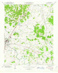
1949 Map of Franklin
USGS Topo · Published 1949About this map
Franklin serves as the focal point of this Williamson County landscape just after the mid-century, where the Harpeth River winds past several prominent local landmarks. The area's deep historical roots are evidenced by a high density of family and commemorative burial grounds, including the Confederate Cem and Mc Gavock Cem near the town center, along with the Rest Haven Cem to the north. Transportation and communication are defined by the Louisville and Nashville railroad corridor and the Radio Tower (WSM) standing near Lipscomb Sch. This period shows a transition from rural farmsteads to established community infrastructure, with small educational centers like Florenceville Sch and Langford Sch serving the surrounding countryside. From the high point at Ropers Knob to the low-lying Mudsink, the map documents a complex network of pikes and gaps, such as Holly Tree Gap, that shaped local travel before the era of modern interstates.
Find a feature on this map
58 named features on this map. Tap any name to fly to it.
Don’t see what you’re looking for? This feature index may not catch every label — zoom into the map to look around manually.
Map Details
Editions of this 1949 Franklin Map
3 editions found

Other maps of this area

1903 · Nashville
USGS Topo · 1:125,000

1909 · Franklin
USGS Topo · 1:62,500

1932 · Hermitage
USGS Topo · 1:62,500

1932 · Nashville
USGS Topo · 1:62,500

1936 · Spring Hill
USGS Topo · 1:24,000

1936 · Bethesda
USGS Topo · 1:24,000

1942 · Lebanon
USGS Topo · 1:100,000

1946 · Leipers Fork
USGS Topo · 1:24,000

1946 · Bethesda
USGS Topo · 1:24,000
1946 · Spring Hill
USGS Topo · 1:24,000
Featured Places
- Franklin, TN
- Brentwood, TN
- Jamestown, Brentwood
- Crockett Cove, Brentwood
- Concord Country Estates, Brentwood