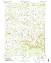
1969 Map of Colley
USGS Topo · Published 1973About this map
Colley and the surrounding highlands of the Bradford Co Sullivan Co line are defined by a complex network of waterways and high ridges. The landscape in 1969 reveals a rural settlement pattern centered on crossroads like Kinsley Corners and the community of Cumiskey. Significant local landmarks include St Francis Ch and St Johns Ch, which along with several isolated Cem sites, provide valuable data for genealogical research in this part of Pennsylvania.
Find a feature on this map
36 named features on this map. Tap any name to fly to it.
Don’t see what you’re looking for? This feature index may not catch every label — zoom into the map to look around manually.
Map Details
Editions of this 1969 Colley Map
2 editions found
Other maps of this area

1891 · Harveys Lake
USGS Topo · 1:62,500

1893 · Harvey Lake
USGS Topo · 1:62,500

1934 · Laporte
USGS Topo · 1:62,500

1943 · Monroeton
USGS Topo · 1:62,500

1945 · Meshoppen
USGS Topo · 1:62,500

1945 · Jenningsville
USGS Topo · 1:24,000

1945 · Laceyville
USGS Topo · 1:24,000

1946 · Dutch Mtn
USGS Topo · 1:24,000

1947 · Jenningsville
USGS Topo · 1:31,680
1947 · Laceyville
USGS Topo · 1:24,000
Featured Places
- Wilmot Township, PA
- Colley Township, PA
- Albany Township, PA
- Cumiskey, Wilmot Township
- Cherry Township, PA