
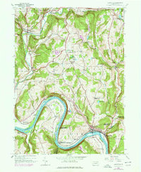
1945 Map of Laceyville
USGS Topo · Published 1971About this map
The Susquehanna River carves a dramatic oxbow at Quicks Bend, anchoring this mid-century survey of the Wyoming and Bradford County border. The village of Laceyville and neighboring Skinners Eddy sit at the river's edge, served by the Lehigh Valley railroad line. The landscape is defined by the high ridges of Tuscarora Mountain and the broad Wyalusing Valley to the northwest, where the settlement of Camptown is situated along Wyalusing Creek.
Find a feature on this map
47 named features on this map. Tap any name to fly to it.
Don’t see what you’re looking for? This feature index may not catch every label — zoom into the map to look around manually.
Map Details
Editions of this 1945 Laceyville Map
2 editions found
Other maps of this area

1923 · Towanda
USGS Topo · 1:62,500

1926 · Towanda
USGS Topo · 1:62,500

1943 · Towanda
USGS Topo · 1:62,500

1943 · Monroeton
USGS Topo · 1:62,500

1943 · Le Raysville
USGS Topo · 1:62,500

1945 · Le Raysville
USGS Topo · 1:62,500

1945 · Meshoppen
USGS Topo · 1:62,500

1945 · Auburn Center
USGS Topo · 1:24,000

1945 · Jenningsville
USGS Topo · 1:24,000

1945 · Meshoppen
USGS Topo · 1:24,000
Featured Places
- Wilmot Township, PA
- Laceyville, PA
- Herrick Township, PA
- Silvara, Tuscarora Township
- Browntown, Wyalusing Township