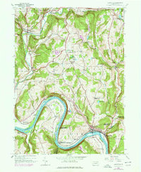
1945 Map of Laceyville
USGS Topo · Published 1977About this map
The Susquehanna River carves a dramatic path through this 1945 landscape, forming the sharp oxbow known as Quicks Bend before reaching the riverside settlements of Laceyville and Skinners Eddy. This rural stretch of the Bradford and Wyoming county line shows a highly developed network of upland farms and small creek-side villages connected by the Lehigh Valley railroad line. Deeply incised valleys like those of Wyalusing Creek and Tuscarora Creek define the settlement patterns, where families established community centers like Camptown and Merryall. Genealogists will find a wealth of local landmarks, from the Lacey Street Cem and Merryall Cem to the isolated Spring Hill Sch. The 1969 revisions, noted in purple, highlight the growth of residential and industrial footprints, particularly near the river flats of Braintrim Valley and the settlement of Browntown.
Find a feature on this map
51 named features on this map. Tap any name to fly to it.
Don’t see what you’re looking for? This feature index may not catch every label — zoom into the map to look around manually.
Map Details
Editions of this 1945 Laceyville Map
2 editions found

Other maps of this area

1923 · Towanda
USGS Topo · 1:62,500

1926 · Towanda
USGS Topo · 1:62,500

1943 · Towanda
USGS Topo · 1:62,500

1943 · Monroeton
USGS Topo · 1:62,500

1943 · Le Raysville
USGS Topo · 1:62,500

1945 · Le Raysville
USGS Topo · 1:62,500

1945 · Meshoppen
USGS Topo · 1:62,500

1945 · Auburn Center
USGS Topo · 1:24,000

1945 · Jenningsville
USGS Topo · 1:24,000

1945 · Meshoppen
USGS Topo · 1:24,000
Featured Places
- Wilmot Township, PA
- Laceyville, PA
- Herrick Township, PA
- Silvara, Tuscarora Township
- Browntown, Wyalusing Township