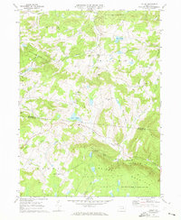
1969 Map of Colley
USGS Topo · Published 1973About this map
Briskey Mountain and the surrounding highlands dominate this part of Pennsylvania, where the border between Bradford and Sullivan Counties meets amidst a network of mountain runs and creeks. Small rural settlements like Wilmot and Cumiskey are centered around local landmarks such as St Francis Church and St Johns Church. The landscape is largely defined by public holdings, including State Game Lands No 142 and State Game Lands No 172, indicating a region that shifted from early agrarian use to conservation and recreation by the late 1960s.
Find a feature on this map
34 named features on this map. Tap any name to fly to it.
Don’t see what you’re looking for? This feature index may not catch every label — zoom into the map to look around manually.
Map Details
Editions of this 1969 Colley Map
2 editions found
Other maps of this area

1891 · Harveys Lake
USGS Topo · 1:62,500

1893 · Harvey Lake
USGS Topo · 1:62,500

1934 · Laporte
USGS Topo · 1:62,500

1943 · Monroeton
USGS Topo · 1:62,500

1945 · Meshoppen
USGS Topo · 1:62,500

1945 · Jenningsville
USGS Topo · 1:24,000

1945 · Laceyville
USGS Topo · 1:24,000

1946 · Dutch Mtn
USGS Topo · 1:24,000

1947 · Jenningsville
USGS Topo · 1:31,680
1947 · Laceyville
USGS Topo · 1:24,000
Featured Places
- Wilmot Township, PA
- Colley Township, PA
- Albany Township, PA
- Cumiskey, Wilmot Township
- Cherry Township, PA