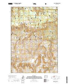
2020 Map of Collins Butte
USGS Topo · Published 2020About this map
Umatilla National Forest dominates this section of the Oregon high country along the border of Morrow and Wheeler Counties. The landscape is defined by its water sources and high elevation points, notably Collins Butte and the surrounding drainages of Wheeler Cr and Davis Cr. A network of forest development roads, including Nat For Dev Rd 2513 and Winlock Rd, provides access to these timberlands and remote meadows like Long Prairie.
Find a feature on this map
43 named features on this map. Tap any name to fly to it.
Don’t see what you’re looking for? This feature index may not catch every label — zoom into the map to look around manually.
Map Details
Editions of this 2020 Collins Butte Map
This is the sole edition of this map. No revisions or reprints were ever made.
Other maps of this area

1953 · Kimberly
USGS Topo · 1:62,500

1953 · Spray
USGS Topo · 1:62,500

1953 · Pendleton
USGS Topo · 1:250,000

1955 · Canyon City
USGS Topo · 1:250,000

1956 · Pendleton
USGS Topo · 1:250,000

1959 · Canyon City
USGS Topo · 1:250,000

1969 · Lefevre Prairie
USGS Topo · 1:24,000
1969 · Lonerock
USGS Topo · 1:24,000

1969 · Chapin Creek
USGS Topo · 1:24,000

1980 · Monument
USGS Topo · 1:100,000