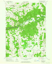
1963 Map of Collins Center
USGS Topo · Published 1965About this map
Cattaraugus Creek winds through the dramatic Zoar Valley, serving as the natural boundary between Erie and Cattaraugus Counties. This mid-century survey captures a rural landscape defined by deep valleys and high points like Scrabble Hill and Hebner Hill. While the settlement at Collins Center serves as a local hub with its water tank and nearby Gas Wells, the map also details numerous small-scale operations including a Gravel Pit and a Pumping Sta. The presence of several family-named cemeteries, such as Knight Cem and Barber Cem, provides specific points of interest for genealogists tracing local lineage. Significant portions of the eastern terrain are dedicated to a State Reforestation Area, indicating a shift in land use toward conservation in the uplands above South Branch Cattaraugus Creek.
Find a feature on this map
47 named features on this map. Tap any name to fly to it.
Don’t see what you’re looking for? This feature index may not catch every label — zoom into the map to look around manually.
Map Details
Editions of this 1963 Collins Center Map
Other maps of this area

1905 · Eden
USGS Topo · 1:62,500

1907 · Eden
USGS Topo · 1:62,500

1923 · Cattaraugus
USGS Topo · 1:62,500

1924 · Ellicottville
USGS Topo · 1:62,500

1925 · Springville
USGS Topo · 1:62,500

1938 · Cattaraugus
USGS Topo · 1:62,500

1941 · Cattaraugus
USGS Topo · 1:62,500

1941 · Ellicottville
USGS Topo · 1:62,500

1944 · Eden
USGS Topo · 1:62,500

1944 · North Collins
USGS Topo · 1:31,680