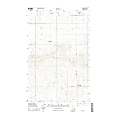
2014 Map of Collins SE
USGS Topo · Published 2014About this map
Teton Ridge dominates the central landscape of this Teton County survey, rising above a network of section lines and rural roads. The area is defined by its agricultural layout, with the Beck Cem serving as a primary point of historical interest for genealogists tracing local family roots in this corner of Montana. The natural drainage of Trail Coulee cuts through the northern sections, providing a topographical break in the high plains terrain. A sparse but intentional road network, including the east-west corridor of Mt-221, connects the various townships of T23N, T24N, and T25N. This survey documents the persistent rural character of the region, where the Public Land Survey System has dictated the placement of roads like 18th Rd NE and 8th Ln NE along the precise boundaries of the high prairie.
Find a feature on this map
22 named features on this map. Tap any name to fly to it.
Don’t see what you’re looking for? This feature index may not catch every label — zoom into the map to look around manually.
Map Details
Editions of this 2014 Collins SE Map
This is the sole edition of this map. No revisions or reprints were ever made.
Other maps of this area

1886 · Great Falls
USGS Topo · 1:250,000

1949 · Vaughn
USGS Topo · 1:62,500

1950 · Fairfield
USGS Topo · 1:62,500

1950 · Dutton
USGS Topo · 1:62,500

1950 · Collins
USGS Topo · 1:62,500

1952 · Vaughn
USGS Topo · 1:62,500

1954 · Great Falls
USGS Topo · 1:250,000

1957 · Great Falls
USGS Topo · 1:250,000

1976 · Great Falls North
USGS Topo · 1:100,000
1983 · Cleiv
USGS Topo · 1:24,000