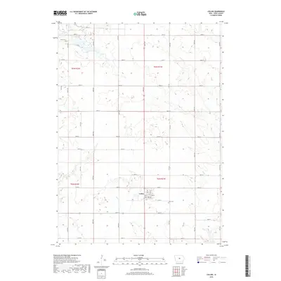
2018 Map of Collins
USGS Topo · Published 2018About this map
Collins serves as the central hub for this portion of southeastern Story County, anchored by its grid of local streets including Main St and 2nd St. The surrounding landscape is defined by a dense network of sectional roads and the serpentine paths of several waterways, such as Wolf Cr and Mud Cr, which drain the agricultural land. This 2018 survey reveals the persistent imprint of nineteenth-century settlement patterns, notably through the preservation of rural burial grounds like Mound Cem in the northwest and Collins Cem just east of the town center. The map illustrates how modern infrastructure, such as Co Hwy E63, follows the historic township lines of t82n r21w and t83n r21w, maintaining the rigid geometry of the original land surveys while small creeks like Willow Cr provide the only deviation from this grid.
Find a feature on this map
42 named features on this map. Tap any name to fly to it.
Don’t see what you’re looking for? This feature index may not catch every label — zoom into the map to look around manually.
Map Details
Editions of this 2018 Collins Map
This is the sole edition of this map. No revisions or reprints were ever made.
Other maps of this area

1954 · Waterloo
USGS Topo · 1:250,000

1954 · Des Moines
USGS Topo · 1:250,000

1955 · Waterloo
USGS Topo · 1:250,000

1956 · Des Moines
USGS Topo · 1:250,000

1957 · Des Moines
USGS Topo · 1:250,000

1969 · Des Moines
USGS Topo · 1:250,000
1972 · Loring
USGS Topo · 1:24,000

1975 · Nevada
USGS Topo · 1:24,000

1975 · Mingo
USGS Topo · 1:24,000

1975 · State Center
USGS Topo · 1:24,000