
1975 Map of State Center
USGS Topo · Published 1978About this map
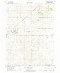
State Center serves as the primary hub of this Iowa landscape, where the Chicago and Northwestern corridor passes through the town center near Hillside Cem and St Josephs Cem. The map reveals a transition in rail infrastructure, noting an Abandoned segment of line running through Clemons and past the village of Bromley. The terrain is defined by the winding paths of Middle Minerva Creek and South Minerva Creek, which carve through the farmland toward the French Grove County Wildlife Area. Local history is anchored by a network of rural landmarks, from the St Johns Ch and its neighboring St Johns Cem to the isolated Sacred Heart Cem near St Anthony. These features, combined with industrial markers like a local Gravel Pit, illustrate the 1970s balance of agriculture, industry, and small-town settlement.
Find a feature on this map
28 named features on this map. Tap any name to fly to it.
Don’t see what you’re looking for? This feature index may not catch every label — zoom into the map to look around manually.
Map Details
Editions of this 1975 State Center Map
This is the sole edition of this map. No revisions or reprints were ever made.
Other maps of this area

1954 · Waterloo
USGS Topo · 1:250,000

1954 · Des Moines
USGS Topo · 1:250,000

1955 · Waterloo
USGS Topo · 1:250,000

1956 · Des Moines
USGS Topo · 1:250,000

1957 · Des Moines
USGS Topo · 1:250,000

1969 · Des Moines
USGS Topo · 1:250,000

1975 · State Center NW
USGS Topo · 1:24,000

1975 · Union
USGS Topo · 1:24,000

1975 · Rhodes
USGS Topo · 1:24,000
1975 · Melbourne
USGS Topo · 1:24,000