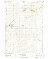
1975 Map of Melbourne
USGS Topo · Published 1978About this map
Melbourne sits at the intersection of two major rail corridors in this mid-1970s survey of Marshall County. The landscape is defined by the Chicago Milwaukee St Paul and Pacific and the Chicago and North Western railroads, which cut through the drainage basins of North Timber Creek and Snipe Creek. Outside the primary settlement of Melbourne, the small community of Van Cleve serves as a secondary focal point near the Van Cleve County Park. This era of the Iowa landscape shows a clear established pattern of agricultural sections, punctuated by local landmarks like Lollar Park and several rural burying grounds, including Maple Grove Cem and Logan Cem. The map provides a detailed look at the drainage systems leading toward the Skunk R in the southwestern corner, reflecting the topography of the Southern Iowa Drift Plain.
Find a feature on this map
17 named features on this map. Tap any name to fly to it.
Don’t see what you’re looking for? This feature index may not catch every label — zoom into the map to look around manually.
Map Details
Editions of this 1975 Melbourne Map
This is the sole edition of this map. No revisions or reprints were ever made.
Other maps of this area

1954 · Waterloo
USGS Topo · 1:250,000

1954 · Des Moines
USGS Topo · 1:250,000

1955 · Waterloo
USGS Topo · 1:250,000

1956 · Des Moines
USGS Topo · 1:250,000

1957 · Des Moines
USGS Topo · 1:250,000

1960 · Marshalltown
USGS Topo · 1:24,000

1960 · Marshalltown
USGS Topo · 1:62,500

1969 · Des Moines
USGS Topo · 1:250,000

1975 · State Center
USGS Topo · 1:24,000

1975 · Rhodes
USGS Topo · 1:24,000