
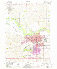
1960 Map of Marshalltown
USGS Topo · Published 1962About this map
The Iowa River cuts a prominent diagonal across this mid-century landscape, framing the growth of Marshalltown as it expanded toward the south and west. The city's residential and civic core is densely detailed, showing the Courthouse, the Soldiers Home complex, and a robust network of neighborhood schools ranging from Hansen Sch to St Marys Sch. Outside the city center, the importance of rail transit is evident where the Chicago and North Western and Chicago Great Western lines converge, supporting local industry and the County Fairground.
Find a feature on this map
64 named features on this map. Tap any name to fly to it.
Don’t see what you’re looking for? This feature index may not catch every label — zoom into the map to look around manually.
Map Details
Editions of this 1960 Marshalltown Map
2 editions found
Other maps of this area

1954 · Waterloo
USGS Topo · 1:250,000

1954 · Des Moines
USGS Topo · 1:250,000

1955 · Waterloo
USGS Topo · 1:250,000

1956 · Des Moines
USGS Topo · 1:250,000

1957 · Des Moines
USGS Topo · 1:250,000

1960 · Marshalltown
USGS Topo · 1:62,500

1960 · Le Grand
USGS Topo · 1:24,000

1960 · Conrad West
USGS Topo · 1:24,000

1960 · Conrad East
USGS Topo · 1:24,000

1969 · Des Moines
USGS Topo · 1:250,000