
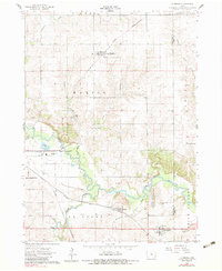
1960 Map of Le Grand
USGS Topo · Published 1962About this map
The winding Iowa River corridor dominates this landscape at the border of Marshall and Tama counties, anchoring a valley of heavy industry and small agricultural hubs. Near the settlement of Le Grand, multiple quarries and a Sandpit indicate the area's geological importance, while the river's path is managed by a Fish Hatchery and Powerplant. The transportation network of the early 1960s is clearly defined by the crossing routes of the Chicago and North Western and Chicago Great Western railroads, which serviced the grain and stone industries of the region.
Find a feature on this map
30 named features on this map. Tap any name to fly to it.
Don’t see what you’re looking for? This feature index may not catch every label — zoom into the map to look around manually.
Map Details
Editions of this 1960 Le Grand Map
2 editions found
Other maps of this area

1954 · Waterloo
USGS Topo · 1:250,000

1954 · Des Moines
USGS Topo · 1:250,000

1955 · Waterloo
USGS Topo · 1:250,000

1956 · Des Moines
USGS Topo · 1:250,000

1957 · Des Moines
USGS Topo · 1:250,000

1960 · Marshalltown
USGS Topo · 1:24,000

1960 · Marshalltown
USGS Topo · 1:62,500

1960 · Conrad West
USGS Topo · 1:24,000

1960 · Conrad East
USGS Topo · 1:24,000

1969 · Des Moines
USGS Topo · 1:250,000