
1975 Map of Union
USGS Topo · Published 1978About this map
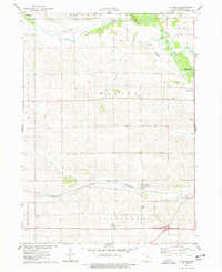
The Iowa River carves a deep valley through the center of this landscape, its winding course defining the transition between Hardin and Marshall counties. In the mid-1970s, the agricultural character of the region remained firmly anchored by the settlements of Union and Liscomb, both connected by the Chicago and North Western railroad. The map provides a detailed view of rural life, specifically through its numerous family-named burial grounds including Miller Cem, Bunch Cem, and Everist Cem, which serve as vital markers for genealogical research. Conservation efforts are evident in the sprawling Grammer Grove County Wildlife Area and the County Forest Reserve along the river bluffs. To the south, Mormon Ridge and Mormon Lake recall historical migration patterns, while the presence of several Gravel Pits indicates the local extractive industry that supported the area's road networks.
Find a feature on this map
31 named features on this map. Tap any name to fly to it.
Don’t see what you’re looking for? This feature index may not catch every label — zoom into the map to look around manually.
Map Details
Editions of this 1975 Union Map
This is the sole edition of this map. No revisions or reprints were ever made.
Other maps of this area

1954 · Waterloo
USGS Topo · 1:250,000

1955 · Waterloo
USGS Topo · 1:250,000

1960 · Marshalltown
USGS Topo · 1:24,000

1960 · Marshalltown
USGS Topo · 1:62,500

1960 · Conrad West
USGS Topo · 1:24,000

1975 · State Center NW
USGS Topo · 1:24,000

1975 · State Center
USGS Topo · 1:24,000
1975 · La Moille
USGS Topo · 1:24,000

1979 · New Providence
USGS Topo · 1:24,000

1979 · Eldora
USGS Topo · 1:24,000