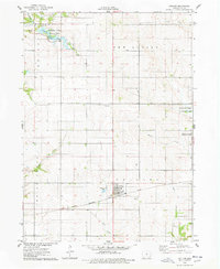
1975 Map of Collins
USGS Topo · Published 1978About this map
The town of Collins sits at the intersection of rural agriculture and mid-century transit, serving as a hub for the Chicago Milwaukee St Paul and Pacific railroad which cuts across the landscape. The surrounding terrain is defined by its drainages, including the prominent Indian Creek and Wolf Creek, which carve through the townships of New Albany and Collins. Local history is anchored by the Collins Cem near the town center and Mound Cem to the northwest.
Find a feature on this map
25 named features on this map. Tap any name to fly to it.
Don’t see what you’re looking for? This feature index may not catch every label — zoom into the map to look around manually.
Map Details
Editions of this 1975 Collins Map
This is the sole edition of this map. No revisions or reprints were ever made.
Other maps of this area

1954 · Waterloo
USGS Topo · 1:250,000

1954 · Des Moines
USGS Topo · 1:250,000

1955 · Waterloo
USGS Topo · 1:250,000

1956 · Des Moines
USGS Topo · 1:250,000

1957 · Des Moines
USGS Topo · 1:250,000

1969 · Des Moines
USGS Topo · 1:250,000
1972 · Loring
USGS Topo · 1:24,000

1975 · Nevada
USGS Topo · 1:24,000

1975 · Mingo
USGS Topo · 1:24,000

1975 · State Center
USGS Topo · 1:24,000