
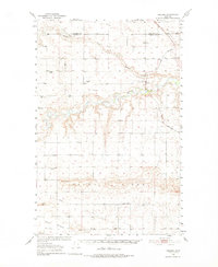
1950 Map of Collins
USGS Topo · Published 1952About this map
Teton River meanders across the center of this mid-century landscape, carving a deep valley that separates the northern plains from the southern highlands. In this period, the Great Northern railroad remains the primary artery for the region's agricultural economy, supporting the small settlement of Collins and the industrial activity at Zim Elevator. The map reveals a highly organized rural infrastructure, with small country schools like Caskey School and South Liberty Sch serving the local farming families.
Find a feature on this map
17 named features on this map. Tap any name to fly to it.
Don’t see what you’re looking for? This feature index may not catch every label — zoom into the map to look around manually.
Map Details
Editions of this 1950 Collins Map
2 editions found
Other maps of this area

1886 · Great Falls
USGS Topo · 1:250,000

1920 · Choteau
USGS Topo · 1:125,000

1920 · Dupuyer
USGS Topo · 1:125,000

1920 · Conrad
USGS Topo · 1:125,000

1938 · Gallup City
USGS Topo · 1:62,500

1942 · Gallup City
USGS Topo · 1:62,500

1949 · Vaughn
USGS Topo · 1:62,500

1950 · Fairfield
USGS Topo · 1:62,500

1950 · Dutton
USGS Topo · 1:62,500

1952 · Vaughn
USGS Topo · 1:62,500