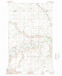
1987 Map of Collins
USGS Topo · Published 1987About this map
Teton River meanders through this portion of the Montana high plains, defining a landscape of riparian curves and expansive coulees. Centered on the small settlement of Collins, the map captures a transition in regional infrastructure during the late 1980s. While the river remains a dominant natural feature, the human footprint is marked by the presence of an Old Railroad and Old RR Grade, indicating the historical importance of rail transport for remote agricultural outposts like Acme. The survey detail reveals the proximity of the Pondera and Teton county line, where Muddy Creek joins the larger river system. This provisional study preserves the layout of these rural communities and their reliance on the local waterways and former rail corridors before further modern development altered the northern prairie landscape.
Find a feature on this map
8 named features on this map. Tap any name to fly to it.
Don’t see what you’re looking for? This feature index may not catch every label — zoom into the map to look around manually.
Map Details
Editions of this 1987 Collins Map
This is the sole edition of this map. No revisions or reprints were ever made.
Other maps of this area

1886 · Great Falls
USGS Topo · 1:250,000

1920 · Conrad
USGS Topo · 1:125,000

1950 · Dutton
USGS Topo · 1:62,500

1950 · Collins
USGS Topo · 1:62,500

1954 · Great Falls
USGS Topo · 1:250,000

1954 · Shelby
USGS Topo · 1:250,000

1957 · Great Falls
USGS Topo · 1:250,000

1958 · Shelby
USGS Topo · 1:250,000

1967 · Brady
USGS Topo · 1:24,000

1967 · Fowler Coulee SW
USGS Topo · 1:24,000