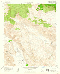
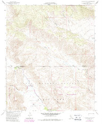
1959 Map of Collins Valley
USGS Topo · Published 1960About this map
Anza-Borrego Desert State Park dominates this late 1950s survey, illustrating the complex drainage systems of the California desert before significant modern development. The landscape is defined by the convergence of steep canyons like Rockhouse Canyon, Alder Canyon, and Salvador Canyon into the central lowlands of Collins Valley. A network of intermittent water sources and vital riparian spots, such as Middle Willows and Lower Willows, are mapped along Coyote Creek, marking the essential stopping points for travelers and wildlife in an otherwise arid environment. The map details the transition from the high elevations of the Santa Rosa Mts and Buck Ridge down to the sandy reaches of Jackass Flat. For those researching local history, the inclusion of several primitive transportation routes, specifically designated as Jeep Trails, provides evidence of the era's backcountry access and desert navigation patterns.
Find a feature on this map
26 named features on this map. Tap any name to fly to it.
Don’t see what you’re looking for? This feature index may not catch every label — zoom into the map to look around manually.
Map Details
Editions of this 1959 Collins Valley Map
5 editions found
Other maps of this area

1901 · Southern California Sheet No. 1
USGS Topo · 1:250,000

1901 · San Jacinto
USGS Topo · 1:125,000

1903 · Ramona
USGS Topo · 1:125,000

1904 · Indio
USGS Topo · 1:125,000

1904 · Southern California Sheet No. 2
USGS Topo · 1:250,000

1904 · Southern California Sheet No. 1
USGS Topo · 1:250,000

1931 · Vallecito
USGS Topo · 1:125,000

1939 · Warner Springs
USGS Topo · 1:62,500

1940 · Hemet Reservoir
USGS Topo · 1:62,500

1941 · Toro Peak
USGS Topo · 1:62,500