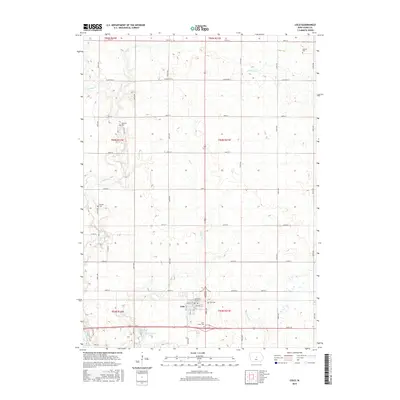
2015 Map of Colo
USGS Topo · Published 2015About this map
Colo stands as the central hub of this Story County landscape, where the intersection of a rigid section-line road grid meets the natural curves of the prairie drainage system. The town's layout is clearly defined by streets such as Main St and Bailey St, while the surrounding countryside is dotted with a high concentration of pioneer and family burial grounds including Sparrow Cem, Oak Hill Cem, Murphy Cem, and Saint James Cem. These sites, alongside the larger Colo Cem, offer significant landmarks for genealogical research in New Albany Township.
Find a feature on this map
34 named features on this map. Tap any name to fly to it.
Don’t see what you’re looking for? This feature index may not catch every label — zoom into the map to look around manually.
Map Details
Editions of this 2015 Colo Map
This is the sole edition of this map. No revisions or reprints were ever made.
Other maps of this area

1954 · Waterloo
USGS Topo · 1:250,000

1954 · Des Moines
USGS Topo · 1:250,000
1955 · Waterloo
USGS Topo · 1:250,000

1956 · Des Moines
USGS Topo · 1:250,000

1957 · Des Moines
USGS Topo · 1:250,000
1969 · Des Moines
USGS Topo · 1:250,000
1975 · Nevada
USGS Topo · 1:24,000
1975 · State Center NW
USGS Topo · 1:24,000
1975 · State Center
USGS Topo · 1:24,000
1975 · Rhodes
USGS Topo · 1:24,000