
1971 Map of Colome
USGS Topo · Published 1974About this map
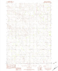
Colome serves as the primary hub of this landscape within the Rosebud Indian Reservation during the early 1970s. The town is situated at the intersection of regional transit, defined by the route of the Chicago and North Western railroad which cuts diagonally across the southwestern corner of the sheet. Outside the town center, the land is organized into named townships or survey blocks such as Plainview, Pleasant View, Irwin, and Colome, reflecting the systematic agricultural partitioning of the South Dakota prairie. The terrain is characterized by the drainage patterns of Bull Creek-Sully in the northeast, while local infrastructure is marked by specific utilities like the Sewage Disposal Ponds and a Gravel Pit near the rail line. This survey captures a moment when the rural township structure remained the dominant social and geographic framework for Tripp County residents.
Find a feature on this map
14 named features on this map. Tap any name to fly to it.
Don’t see what you’re looking for? This feature index may not catch every label — zoom into the map to look around manually.
Map Details
Editions of this 1971 Colome Map
This is the sole edition of this map. No revisions or reprints were ever made.
Other maps of this area

1955 · Mitchell
USGS Topo · 1:250,000

1959 · Mitchell
USGS Topo · 1:250,000

1964 · Dallas
USGS Topo · 1:24,000

1964 · Dallas NW
USGS Topo · 1:24,000

1971 · Rattlesnake Butte East
USGS Topo · 1:24,000

1971 · Rattlesnake Butte West
USGS Topo · 1:24,000

1971 · Colome SE
USGS Topo · 1:24,000

1982 · Winner North
USGS Topo · 1:25,000

1982 · Winner South
USGS Topo · 1:25,000
1982 · Wewela NE
USGS Topo · 1:24,000