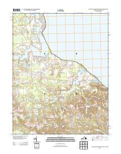
2013 Map of Colonial Beach South
USGS Topo · Published 2013About this map
Monroe Cr and Monroe Bay carve into the Northern Neck landscape here, defining a waterfront where small landings and geographic points once drove the local economy. Along the shores of the Potomac River, names like Stave Landing, Trotts Point, and Church Point hint at generations of maritime and community life. Further inland, the map shows the transition from tidal creeks to extensive wetlands such as The Big Swamp and Flamstead Hill Swamp.
Find a feature on this map
122 named features on this map. Tap any name to fly to it.
Don’t see what you’re looking for? This feature index may not catch every label — zoom into the map to look around manually.
Map Details
Editions of this 2013 Colonial Beach South Map
This is the sole edition of this map. No revisions or reprints were ever made.
Other maps of this area

1889 · Fredericksburg
USGS Topo · 1:125,000

1892 · Fredericksburg
USGS Topo · 1:125,000

1892 · Montross
USGS Topo · 1:62,500

1894 · Wicomico
USGS Topo · 1:62,500

1894 · Fredericksburg
USGS Topo · 1:125,000

1895 · Wicomico
USGS Topo · 1:62,500

1895 · Nomini
USGS Topo · 1:125,000

1895 · Montross
USGS Topo · 1:62,500

1898 · Nomini
USGS Topo · 1:125,000

1902 · Wicomico
USGS Topo · 1:62,500