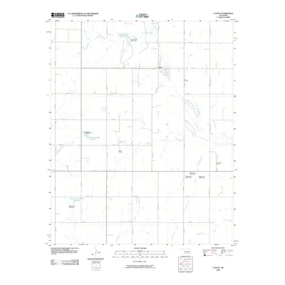
2009 Map of Colony
USGS Topo · Published 2009About this map
Colony sits at the heart of this rural Oklahoma landscape, serving as a focal point for a region defined by its creek-fed drainages and agricultural section lines. This early 21st-century survey reveals a highly managed hydrological system, where numerous small reservoirs and dams, such as the Oknoname 149036 Reservoir and Cobb Creek Site 2 Reservoir, punctuate the landscape to support the local water table and livestock. Cultural landmarks include the Indian Cemetery and Red Top Cemetery, which offer valuable points of interest for genealogists and local historians tracing family lineages in Washita County. The terrain is marked by the winding paths of Buck Creek and Cobb Creek, while the presence of the Lawrence Airport and a grid of rural roads like Payne Lake Rd facilitate regional movement.
Find a feature on this map
34 named features on this map. Tap any name to fly to it.
Don’t see what you’re looking for? This feature index may not catch every label — zoom into the map to look around manually.
Map Details
Editions of this 2009 Colony Map
This is the sole edition of this map. No revisions or reprints were ever made.
Other maps of this area

1955 · Clinton
USGS Topo · 1:250,000

1956 · Cordell
USGS Topo · 1:62,500

1957 · Clinton
USGS Topo · 1:250,000

1961 · Gotebo
USGS Topo · 1:62,500

1961 · Eakly
USGS Topo · 1:62,500

1961 · Carnegie
USGS Topo · 1:62,500
1983 · Corn
USGS Topo · 1:24,000

1983 · Cloud Chief
USGS Topo · 1:24,000

1984 · Eakly
USGS Topo · 1:24,000
1984 · Colony
USGS Topo · 1:24,000