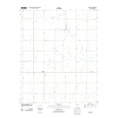
2012 Map of Colony
USGS Topo · Published 2012About this map
Colony serves as the primary hub of this rural landscape, where the local street grid including Watan Ave and Arapaho Ave meets the north-south corridor of N2420 Rd. The surrounding countryside is defined by a dense network of watercourses, most notably Cobb Cr and its associated Cobb Cr Site 2 Reservoir, which feed into a broader drainage system including Buck Cr and Taylor Cr. For those tracing local heritage, several burial sites are preserved across the sections, including the Indian Cem to the southeast of town and the Red Top Cem located near Friendship Cr. At the southern edge of the map, Cowden Junction and Van Dyke Cem mark a crossing of routes near Gyp Cr, while the Lawrence Airport provides a modern navigational point in the eastern reaches.
Find a feature on this map
34 named features on this map. Tap any name to fly to it.
Don’t see what you’re looking for? This feature index may not catch every label — zoom into the map to look around manually.
Map Details
Editions of this 2012 Colony Map
This is the sole edition of this map. No revisions or reprints were ever made.
Other maps of this area

1955 · Clinton
USGS Topo · 1:250,000

1956 · Cordell
USGS Topo · 1:62,500

1957 · Clinton
USGS Topo · 1:250,000

1961 · Gotebo
USGS Topo · 1:62,500

1961 · Eakly
USGS Topo · 1:62,500

1961 · Carnegie
USGS Topo · 1:62,500
1983 · Corn
USGS Topo · 1:24,000

1983 · Cloud Chief
USGS Topo · 1:24,000

1984 · Eakly
USGS Topo · 1:24,000
1984 · Colony
USGS Topo · 1:24,000