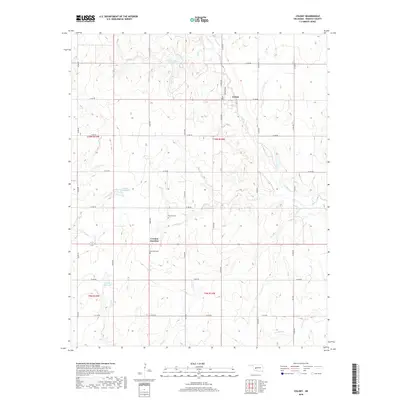
2018 Map of Colony
USGS Topo · Published 2018About this map
Colony is situated in eastern Washita County, serving as a focal point for a region defined by agricultural sections and winding creek beds. The landscape is structured by a grid of rural roads like Watan Ave and Arapaho Ave, which intersect the north-south section lines. To the south lies Cowden Junction, a crossroads marking the transition toward more varied drainage systems. This 2018 survey reveals a terrain carved by the Cobb Creek watershed, which includes the Cobb Creek Site 2 Reservoir and several smaller unnamed catchments like 149036 Reservoir. Local history is anchored by the presence of the Red Top Cemetery and Van Dyke Cemetery, providing essential landmarks for genealogists. The water network is particularly intricate here, with Bull Creek, Gup Creek, and Taylor Creek all contributing to the drainage of these central Oklahoma plains.
Find a feature on this map
35 named features on this map. Tap any name to fly to it.
Don’t see what you’re looking for? This feature index may not catch every label — zoom into the map to look around manually.
Map Details
Editions of this 2018 Colony Map
This is the sole edition of this map. No revisions or reprints were ever made.
Other maps of this area

1955 · Clinton
USGS Topo · 1:250,000

1956 · Cordell
USGS Topo · 1:62,500

1957 · Clinton
USGS Topo · 1:250,000

1961 · Gotebo
USGS Topo · 1:62,500

1961 · Eakly
USGS Topo · 1:62,500

1961 · Carnegie
USGS Topo · 1:62,500
1983 · Corn
USGS Topo · 1:24,000

1983 · Cloud Chief
USGS Topo · 1:24,000

1984 · Eakly
USGS Topo · 1:24,000
1984 · Colony
USGS Topo · 1:24,000