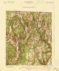
1941 Map of Colrain
USGS Topo · Published 1941About this map
Colrain and the neighboring hills of Franklin County are depicted here in a landscape defined by the branching waters of the North River. The river valleys are dotted with mill-era hamlets like Griswoldville, Shattuckville, and Lyonsville, which thrived alongside the waterway's power. Higher elevations such as Colwell Hill and Franklin Hill provide a stark contrast to the concentrated activity on the valley floor. Historical defense points are clearly marked, with the Site of Fort Morrison, Site of Fort Lucas, and Site of Fort Morris identifying earlier colonial frontier fortifications. To the south, the Mohawk Trail skirts the edge of the Deerfield River, while local life is evidenced by institutions like West Leyden Sch and several remote graveyards including the Chandler Hill Cem. The presence of a CCC Camp reflects the early 1940s era of public works and forest conservation in western Massachusetts.
Find a feature on this map
70 named features on this map. Tap any name to fly to it.
Don’t see what you’re looking for? This feature index may not catch every label — zoom into the map to look around manually.
Map Details
Editions of this 1941 Colrain Map
2 editions found
Other maps of this area

1886 · Hawley
USGS Topo · 1:62,500

1889 · Wilmington
USGS Topo · 1:62,500

1890 · Hawley
USGS Topo · 1:62,500

1890 · Greenfield
USGS Topo · 1:62,500

1891 · Wilmington
USGS Topo · 1:62,500

1891 · Brattleboro
USGS Topo · 1:62,500

1893 · Brattleboro
USGS Topo · 1:62,500

1894 · Greenfield
USGS Topo · 1:62,500

1894 · Hawley
USGS Topo · 1:62,500

1899 · Wilmington
USGS Topo · 1:62,500