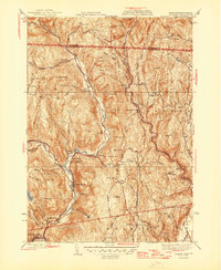
1946 Map of Colrain
USGS Topo · Published 1946About this map
The North River and its various branches carve through this upland terrain just after the second World War, defining a landscape of narrow valleys and steep hills along the Vermont border. Small industrial and residential pockets like Griswoldville and Shattuckville line the river banks, while the East Branch North River and West Branch North River converge near Colrain. This 1946 edition highlights the historical depth of the region by marking colonial defensive positions such as the Site of Fort Morrison, the Site of Fort Lucas, and the Site of Fort Morris. The map preserves the locations of numerous family-named landmarks and rural institutions, from Aunt Sophies Peak and Catamount Hills to the East Colrain Ch and various hilltop burial grounds like the Chandler Hill Cem. These details illustrate a mid-century community still deeply tied to its topographic layout and historical frontier roots.
Find a feature on this map
92 named features on this map. Tap any name to fly to it.
Don’t see what you’re looking for? This feature index may not catch every label — zoom into the map to look around manually.
Map Details
Editions of this 1946 Colrain Map
2 editions found
Other maps of this area

1886 · Hawley
USGS Topo · 1:62,500

1889 · Wilmington
USGS Topo · 1:62,500

1890 · Hawley
USGS Topo · 1:62,500

1890 · Greenfield
USGS Topo · 1:62,500

1891 · Wilmington
USGS Topo · 1:62,500

1891 · Brattleboro
USGS Topo · 1:62,500

1893 · Brattleboro
USGS Topo · 1:62,500

1894 · Greenfield
USGS Topo · 1:62,500

1894 · Hawley
USGS Topo · 1:62,500

1899 · Wilmington
USGS Topo · 1:62,500