
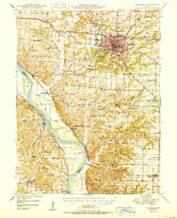
1950 Map of Columbia
USGS Topo · Published 1950About this map
Columbia serves as the mid-century hub of this central Missouri landscape, where the Kansas City and St Louis RR and institutional landmarks like Memorial Stadium and the State Hospital reflect the city's growth. To the southwest, the Missouri River carves a wide path through the terrain, flanked by a complex of levees and rail lines including the Missouri Kansas and Texas RR. The riverfront is dotted with small riverside settlements such as Lupus, McBaine, and Easley, which served as vital transit points before modern highway dominance.
Find a feature on this map
100 named features on this map. Tap any name to fly to it.
Don’t see what you’re looking for? This feature index may not catch every label — zoom into the map to look around manually.
Map Details
Editions of this 1950 Columbia Map
2 editions found
Other maps of this area

1886 · Jefferson City
USGS Topo · 1:125,000

1888 · Boonville
USGS Topo · 1:125,000

1890 · Moberly
USGS Topo · 1:125,000

1890 · Glasgow
USGS Topo · 1:125,000

1894 · Jefferson City
USGS Topo · 1:125,000

1917 · Sturgeon
USGS Topo · 1:62,500

1935 · Columbia
USGS Topo · 1:24,000

1939 · Jefferson City
USGS Topo · 1:62,500

1940 · Columbia
USGS Topo · 1:24,000

1942 · Jefferson City
USGS Topo · 1:62,500