1949 Map of Columbia
USGS Topo · Published 1949About this map
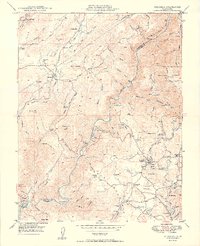
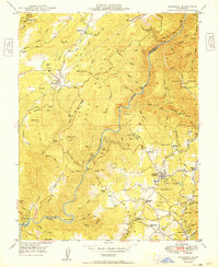
Columbia State Park serves as the focal point of this Gold Country landscape, where the town of Columbia remains a preserved link to the mid-19th-century mining era. The 1949 topography reveals a terrain deeply altered by hydraulic and hard-rock extraction, evidenced by the numerous excavations and water-management systems like the O'Neil Ditch and Mormon Ditch. The Stanislaus River carves through the center, separating the mining districts of Vallecito and Douglas Flat from the southern settlements. Local geography is defined by prominent landmarks such as Table Mountain and subterranean features like Moaning Caves. Small, labor-focused settlements such as Squabbletown and Shaws Flat are mapped alongside active industrial sites, including the Marble Quarries and the Carson Hill Mine, illustrating the persistent mineral economy that shaped Tuolumne and Calaveras counties long after the initial gold rush.
Find a feature on this map
111 named features on this map. Tap any name to fly to it.
Don’t see what you’re looking for? This feature index may not catch every label — zoom into the map to look around manually.
Map Details
Editions of this 1949 Columbia Map
2 editions found
Other maps of this area

1889 · Jackson
USGS Topo · 1:125,000

1891 · Big Trees
USGS Topo · 1:125,000

1892 · Jackson
USGS Topo · 1:125,000

1893 · Sonora
USGS Topo · 1:125,000

1894 · Big Trees
USGS Topo · 1:125,000

1896 · Sonora
USGS Topo · 1:125,000

1897 · Jackson
USGS Topo · 1:125,000

1897 · Sonora
USGS Topo · 1:125,000

1897 · Big Trees
USGS Topo · 1:125,000

1898 · Sonora
USGS Topo · 1:125,000