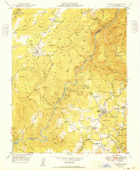
1949 Map of Columbia
USGS Topo · Published 1949About this map
Columbia State Park serves as a preserved centerpiece in this late-1940s landscape, reflecting the region's deep gold-mining heritage. The map records a dense network of claims and works, from the Golden River Mine in the north to the Springfield Mine and Experimental Mine further south. The geological prominence of Table Mountain and the canyon of the Stanislaus River dominate the terrain, creating a backdrop for historic settlements like Vallecito and Douglas Flat.
Find a feature on this map
99 named features on this map. Tap any name to fly to it.
Don’t see what you’re looking for? This feature index may not catch every label — zoom into the map to look around manually.
Map Details
Editions of this 1949 Columbia Map
2 editions found
Other maps of this area

1889 · Jackson
USGS Topo · 1:125,000

1891 · Big Trees
USGS Topo · 1:125,000

1892 · Jackson
USGS Topo · 1:125,000

1893 · Sonora
USGS Topo · 1:125,000

1894 · Big Trees
USGS Topo · 1:125,000

1896 · Sonora
USGS Topo · 1:125,000

1897 · Jackson
USGS Topo · 1:125,000

1897 · Sonora
USGS Topo · 1:125,000

1897 · Big Trees
USGS Topo · 1:125,000

1898 · Sonora
USGS Topo · 1:125,000