2001 Map of Columbia
USGS Topo · Published 2004About this map
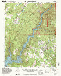
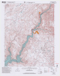
Columbia State Historic Park anchors the southeastern portion of this map, preserving a landscape deeply scarred and shaped by gold-rush era hydraulics and hard-rock mining. The surrounding terrain is defined by the steep canyon of the Stanislaus River and the high, flat-topped Table Mountain, which together dictated the layout of early transportation routes like Parrotts Ferry Road. Historic mining settlements such as Vallecito, Springfield, and Shaws Flat are shown alongside their corresponding industrial remnants, including the Golden River Mine and various Marble Quarries.
Find a feature on this map
85 named features on this map. Tap any name to fly to it.
Don’t see what you’re looking for? This feature index may not catch every label — zoom into the map to look around manually.
Map Details
Editions of this 2001 Columbia Map
2 editions found
Other maps of this area

1889 · Jackson
USGS Topo · 1:125,000

1891 · Big Trees
USGS Topo · 1:125,000

1892 · Jackson
USGS Topo · 1:125,000

1893 · Sonora
USGS Topo · 1:125,000

1894 · Big Trees
USGS Topo · 1:125,000

1896 · Sonora
USGS Topo · 1:125,000

1897 · Jackson
USGS Topo · 1:125,000

1897 · Sonora
USGS Topo · 1:125,000

1897 · Big Trees
USGS Topo · 1:125,000

1898 · Sonora
USGS Topo · 1:125,000