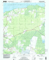
1998 Map of Columbia East
USGS Topo · Published 2001About this map
The Tyrrell County seat of Columbia serves as the focal point for this survey, situated where the swampy coastal interior meets the broad Albemarle Sound. The landscape is defined by low-lying wetlands and ridges, such as Dillion Ridge and the extensive Big Savanna, illustrating the drainage patterns of Riders Creek and Second Creek. These waterways and the nearby Alligator River shaped the development of small communities like Newfoundland and Soundside.
Find a feature on this map
25 named features on this map. Tap any name to fly to it.
Don’t see what you’re looking for? This feature index may not catch every label — zoom into the map to look around manually.
Map Details
Editions of this 1998 Columbia East Map
This is the sole edition of this map. No revisions or reprints were ever made.
Other maps of this area

1906 · Hertford
USGS Topo · 1:62,500

1940 · Hertford
USGS Topo · 1:62,500

1940 · Wade Point
USGS Topo · 1:62,500

1943 · Wade Point
USGS Topo · 1:62,500

1943 · Columbia
USGS Topo · 1:125,000

1948 · Wade Point
USGS Topo · 1:62,500

1953 · Norfolk
USGS Topo · 1:250,000

1953 · Columbia East
USGS Topo · 1:24,000

1953 · Scotia
USGS Topo · 1:24,000

1953 · Columbia West
USGS Topo · 1:24,000